Treasure Map

In 2017 my wife and I drove to Idaho to see the solar eclipse, and we spent a weekend in Sacramento on the way. That Saturday we visited the state capitol building and saw what I imagine are the typical things to see; the Assembly and Senate chambers, the restored historical offices, the governors’ portraits (including the excellent portrait of Jerry Brown by Don Bachardy). Something we saw that I didn’t expect was an exhibition of items from the California State Library. And one of the artifacts they had on display was worth the trip all by itself.

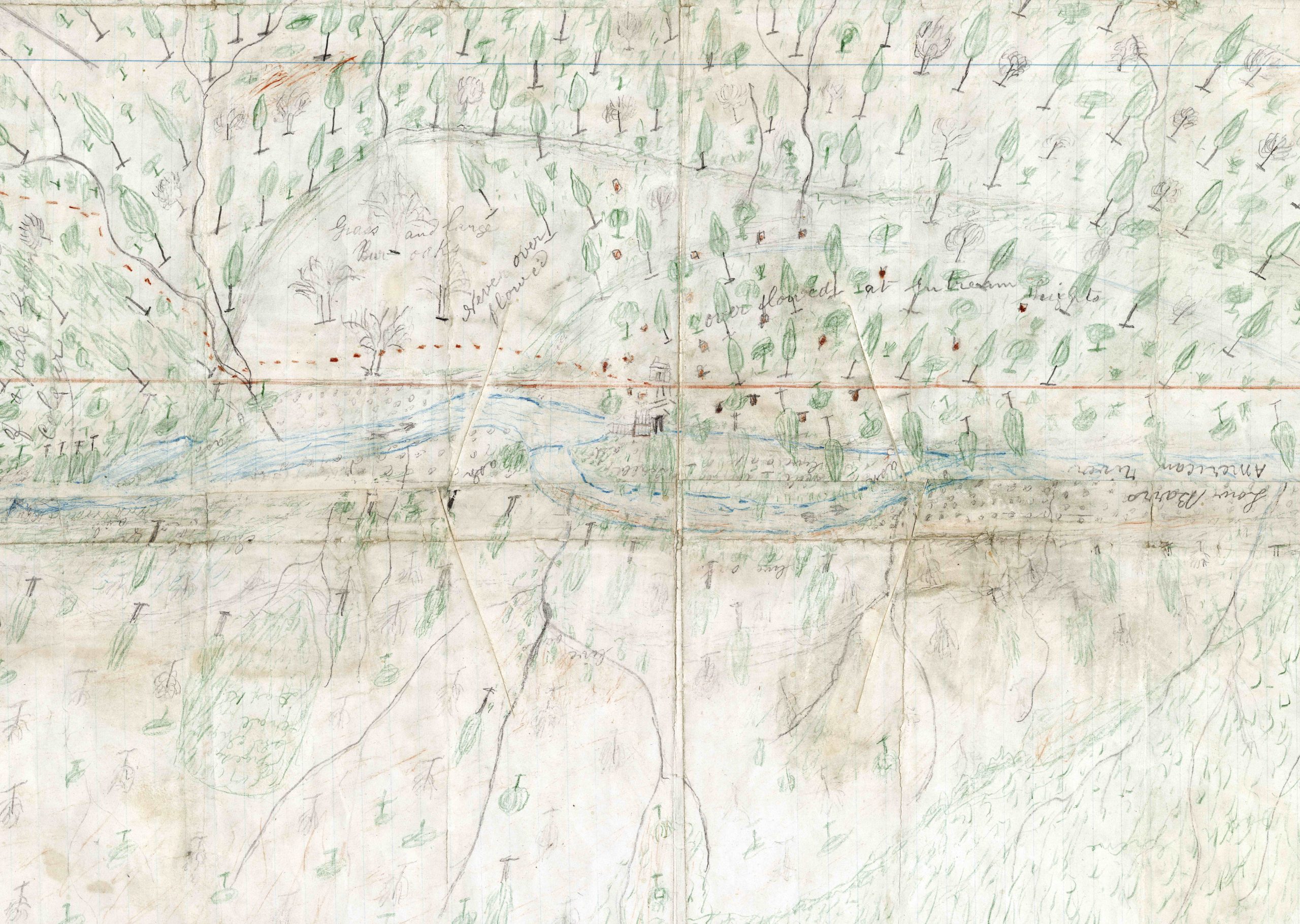
The exhibits were spread among several rooms of glass cases. One of the items on display was a crude hand drawn map in colored pencil. It showed what appeared to be a river surrounded with little drawings of individual trees. It was the perspective that caught my eye – the tree tops all pointed away from the center of the page instead of toward the top. I think the intent was to suggest the topography of the land around the river. But to me it seemed as if it was a view from directly overhead, with the trees flattened as if by an explosion from the tiny structure drawn in the middle of the page.

As it happened, something historic did occur in that river, and it was more dramatic and far reaching than an explosion. The river pictured in the map was the American River near Coloma in January 1848, and the mapmaker was James Marshall. The occasion was Marshall’s discovery of gold while overseeing the construction of a sawmill for John Sutter. This event contributed to California’s rapid admission to the United States without the typical period as a territory and changed the landscape of the West (and the rest of the United States) virtually overnight.

I’ve attached a .jpg of the map that I made from the .tif on the State Library’s website here. The original is here but is over 200 MB so you might want to look at the .jpg first. I’ve also found a photo of what is believed to be the first piece of gold Marshall found, which is in the collection of the Smithsonian in Washington.

The label near another drawing (also by Marshall) read “This crude pencil drawing … delineates perhaps the most important event in California history in the discoverer’s own hand.” There’s nothing I can add to that.

Highway Signs

California highway sign

Something that puzzled me about California for a long time was the state highway sign. I didn’t even know what to call the triangular, somewhat rounded but pointy on top shape, let alone what it was supposed to represent.

My wife and I have lived in a number of states and driven in quite a few more, and I’d noticed that places often indicate something about themselves in the design of the signs identifying their state highways. The signs in Utah have the silhouette of a beehive. Pennsylvania has a keystone. Washington State has a profile of the first President. Wyoming has the “Bucking Horse and Rider” (a registered trademark). New Mexico has the Zia sun from the state flag. Colorado has a symbol from their flag, too. State outlines are also popular; Missouri, Ohio, Florida and Texas are a few (although the Texas outline shows up on “farm-to-market” and “ranch-to-market” roads instead of the state highways). I guess if Colorado or Wyoming used the shapes of their states on the highway signs no one would be able to tell.

On my first visit to California, as soon as I drove away from the airport I noticed the pointy shape of the green state highway symbol. I wondered about it for a bit and I forgot about it when I left. It would be noticed (and forgotten) again on other visits. Then we moved here and I decided I needed to find out what the shape of the sign meant.

This was before a web search was the way to learn things, so I started with my coworkers. Most of them were born in California, but no one seemed to know. I heard guesses from “the top of an acorn” to “a bishop’s hat”. None of it sounded plausible to me. I asked other friends and acquaintances with no more success. So I decided to call the people who I thought would be most likely to know – the owners of the signs.

My call to the first number for CalTrans I could find in a telephone book went something like this:

Me: I’m calling about the shape of the state highway sign.

CalTrans: Is there a specific sign you’re calling about? Do you have a route number and mile marker?

Me: No, I’m asking in general. What does the shape mean?

CalTrans: It means you’re on a state highway.

Me, after a pause: But what does that shape represent? That roughly triangular green shape that’s pointed on the top? What is it supposed to be?

CalTrans, after a pause: I don’t know.

I guess at that point I should have tried to talk to someone else at a different phone number but I didn’t. I got distracted and forgot about it again.

Much later, I was at the website 50states.com (researching something very important, no doubt) and I found the answer. Unfortunately, the site has changed so I can’t link to the exact spot.

The answer was the original sign shape had the bottom round “corners” as right angles and was intended to be mounted on a post instead of a freeway overhead. This makes the sign and post look like a shovel, with the mystery shape representing the blade. This commemorates the ’49ers coming to the Gold Rush with their shovels. I’ve also read a legend that shovels were used to mark the miners’ trails, although I can’t imagine dragging a shovel across the continent to leave it along a trail where someone else without a shovel would probably take it.

It’s easy enough today to do a web search for “California state highway sign shape” and get much more of the story. KCET has a good article here.